Showing posts with label Destinations. Show all posts

Wednesday, 9 August 2017

White Desert Protectorate - Frafra

White Desert Protectorate - Frafra 

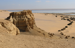
People who have visited white desert say it’s a truly magical place that’s hard to leave. It’s one of the more recently declared protected areas of Egypt which lies totally within the depression of Farafra. Most people who come to visit the Farafra oasis pay visit to the White desert that lies in the area north to the Qasr el Farafra. The spectacular scenery of the place makes it even more popular among tourists. The white chalk of the depression is dotted with inselbergs embedded with numerous fossil seashells. Also the ground here is scattered with thousands of oxidized iron pyrites concretions. Two small and inhabited oases make up for the protectorate which are Wadi Hennis and Karawein Depression.


Natural wealth

The protectorate is a home to a very large and old specimen of Acacia nilotica which make place very important scientifically. Also in the area you can find animals like The Slender-horned Gazelle, Gazella leptoceros. The place overall is a very popular area for tourists and residents who come to enjoy its unique scenery. At some point of time the desert was a habitat for many roaming herds of elephant, giraffe, gazelle and other animals, the desert would have been a savannah with lush green areas and lakes full of fish. The place seems to be an ideal hunting ground for pre-historic man.


The many formation found here

At White Desert you can find many unique and spectacular formations which have been designated some unique descriptive names and have been sculpted by the harsh winds flowing in the desert which have helped the formations get carved into weird shapes that keep constantly changing over time. Here you can find formations like ‘monoliths’ and ‘mushrooms’, ‘ice cream cones’, ‘tents’ and ‘crickets’, as well as the majestic conical flat-topped ‘inselbergs’, to name but a few of the formations.


More about the protectorate

White desert, now a protectorate, is like a natural wonder of Egypt and is referred as the White desert Park. The outer parts nearest the road are known as the Old Desert and can be reached in a normal vehicle. The place manages to attract a large number of tourists who often choose an overnight camping safari, which helps them in witnessing the contrast of both sunset and dawn. The new tracks here have been laid out to help vehicles which pass this famous landmark see the same. The place is initially a field of giant ‘mushrooms’, followed by an ancient lone Acacia tree.

It’s often said that night at the protectorate spend under the stars is an experience never forgotten. As the sky turns pink then deepest fiery orange, the rock-shapes fade and silence is all around. You can enjoy thoroughly while sitting around a small fire and enjoying the simplest meal of chicken, rice and vegetables. If the moon is near full, the white chalk rock shapes glow eerily.

The White Desert is a place that is very hard to leave. It’s bound to offer you a truly magical experience. The protectorate is justifiably the most well-known desert destination in Egypt - and for a good reason.

Wadi El Gemal National Park Protectorate - Marsa Alam

Wadi El Gemal National Park Protectorate - Marsa Alam near Hamata

Wadi el Gamal protected area near Hamata in Egypt is a national park that covers an area of 60 km including the Wadi Gemal islands, red sea coast, coral reefs, sea grass beds and mangroves. The area has more than 450 species of corals and here over 1200 species of fishes can be found. The protectorate is where you can still find ibex and gazelles. The sea grass beds seem to be the habitat where you can find many engendered animals like Dugong, Dugong dugon, and Green Turtle, Chelonia mydas, which nests on the coast and islands.

The start of Wadi Gemal has a fresh water stream that is flowing which joins with seawater forming a low salinity marsh that ideally supports reed beds and Dom palms. At the inside there the Balanites aegyptiaca, dominate; further inland is the Toothbrush Bush, Salvadora persica.


An ideal place for tourists

In order to attract more tourists to the place the same is being promoted largely for eco tourism and due to this privately owned eco lodge has already been built here, also a camp named El-Fustta has been set in the protectorate. Trips which exclusively aim at wildlife and bird watching and some popular camel trips are also organized by many tour operators here. At the park you can also witness prehistoric rock art that contains Ptolemaic and Roman ruin. Also the mountain Mons Smaragdus is the site of small mining communities which seem to have existed from the Pharaonic Egyptian era.


Natural wealth found here

About 17% of the marine life at Wadi Gemal is native to the Red sea. The islands are a breeding ground for 13 bird species and local sea grasses are important food source for some endangered species as well. Wadi el Gemal is one of the most celebrated and thriving national marine parks in Egypt and lies just to the north of Hamata and Berenice.


The park is also touted to be the largest nestling colony of the sooty falcon on globe. The rich wealth of coral reefs found here is speculated to be the most amazing one in the world in terms of abundance of life and diversity of species.

More about Wadi El Gemal Protectorate

The area is said to have well known to the pharaohs who based their great wealth on the treasure mined in these mountains. During the Ptolemaic period, elephants which were captured in Africa were brought to the Park that were then used in military campaigns. These land routes were vital, as it was very tough to sail north against the Red Sea’s prevailing winds, and hazardous to navigate its coral reefs and shoals. The traders and travelers of the region left a legacy of unique antiquities, many of which are still being discovered today. The area is inhabited by pastoral people, The Ababda who still maintains their traditional lifestyle.

The area of the Wadi el Gemal today is well protected by a series of strict environmental laws and conservation organizations.

Siwa Oasis Protectorate- Siwa

Siwa Protected Area

Siwa one of the most inaccessible oases of Egypt till recently is considered to be the most fascinating as well. Its location 60 feet below sea level makes it even more attractive among desert daydreamers. The oasis seems to have its mentioning at 331 BC during the visit of Alexandria the Great who consulted Oracle of Amun. The oasis is located just 50 km from the border of Libya and is populated densely with olive and palm trees. The place is very important for its faunal and cultural diversity. Scattered all over the oasis are crystal-clear springs, which are a heavenly break from the harsh heat.


The rich natural wealth of Siwa

The oasis is covered with a number of lakes and around thousands of springs but the water is still saline supporting very little agriculture and crops which can be grown here are dates, olives and a few vegetable. Siwa oasis is a home to some endangered species of animal which are Slender-horned Gazelle, Gazella leptoceros, and Fennec Fox, Vulpes zerda. Also the place is a natural habitat to the Cheetah, Acinonyx jubatus, one of the most threatened cats in the world. Typical birds which can be found here include the Turtle Dove, Streptopelia


A famous tourist destination

The Siwa oasis is looked upon as a famous tourist destination of Egypt which has even pushed in becoming a protectorate whose design has already been made and will be finished soon. To promote eco tourism in Egypt two privately owned, world class eco-lodges in the oasis have also been built. The oasis seems to have a pleasant climate which gets chilling in winter and hot in the summer while the spring sees a moderate climate.


The unique tradition of Siwa

The geographical location and inaccessibility of Siwa has helped in standing here a unique society which still seems unique from the mainstream Egyptian culture. People here are very traditional and girls are still said to get married here by the age of 14. Siwa was considered independent a few hundred years ago. For hundreds of years the oasis had connection only with few caravan traders that passed along this way via Qara, Qattara and Kerdassa and the occasional determined pilgrim seeking the famous Oracle of Amun. Today, local traditions and Siwi, the local Berber language, still dominates the protectorate.

How to get to Siwa Oasis

Getting to the Siwa oasis now seems easy as there are many international flights which can take you to Cairo through which you can find many tours organized by tour operators. Also you can choose to travel to the location through a bus or a service taxi as well. Also reaching Siwa from Alexandria is easy which has a direct bus as well as a connecting one through Mersa Matrouh as well.

Siwa oasis is famous for its dates and olives, and is one of the most beautiful landscapes in Egypt. An interesting fact about this place is that every October there is a three-day festival during which Siwans must settle all of their past year's disputes.

Wadi Degla Protectorate - Cairo

Wadi Degla Protectorate - Cairo

Wadi Degla area in Cairo governorate was declared as a protectorate in the year 1999 and covers a land area of 60 square km. The Egyptian Environmental Affairs Agency designated Wadi Degla as a protectorate area in 1999. This is a desert type protected land area which is very easily reachable from Cairo and lies just 10 km away. The protectorate is also one of the most important valleys that extends from east to west and rises in the mountains of the eastern desert. The Wadi runs through limestone terrain which then cuts into a deep winding canyon and at few places you can see the floodwater which has carved the rocks into spectacular shapes. Here you can find many fossils in the rock formations and scattered patches of petrified wood.


The ephemeral plants dominate the wadi after the rainy season. Few animal species that have been found here include Dorcas Gazelle, Gazella dorcas, and Nubian Ibex, Capra nubiana, also Lesser Mouse-tailed Bats, Rhinopoma hardwickii, live in the caves in the wadi sides.

A definite place to visit

The protectorate is a very popular destination among tourists who are looking for Cairenes and also people who wish to get away from the hustle bustle of daily life. Also for birdwatchers the place has much to offer. Still those in search of solace and relaxation can also enjoy here thoroughly.


Flara and Fauna

The valley has a group of animals living here which include mammals like dear , taital , mountain rabits , red fox , feather tailed rat , oviparous , barbed rat, little tailed bat and others. Among the insects there are many others. 18 species of reptiles have been recorded as well. Apparently, Wadi Degla is a home to various species of birds, reptiles and bats, and even larger animals such as foxes and gazelles. There are also many fossils from times past when the valley was covered with water.


A great trailing spot

The Wadi provides an excellent trail network for all skill levels. The main trail here of 10.5 km is fun and easy and begins at the wadi gate. The terrain is light sand and gravel with rough sections and thick sand present occasionally but there is not much difficulty for beginners as well. For intermediate to advanced level trailers the wadi’s south and north plateaus seem ideal which provide a vast network of trails that is sure to satisfy advanced riders.

Wadi Degla is your place

Wadi Degla overall is an almost pristine escape. The air at the protectorate feels clean and temperatures are noticeably cooler than in Downtown Cairo. The area is completely quiet and the city appears impossibly far in the distance. Wadi Degla has something for everyone; whether you are an avid runner or somebody who just wants to take in the expansive desert views. If you seek an adventure, Wadi Degla is your place. Wadi Degla is open every day until 6PM. Entrance costs 5LE for foreigners and 3LE for Egyptians. Getting to the place is very easy due to its ideal location and great connectivity.

Wadi El Rayan Protectorate - El Fayoum

Wadi El Rayan Protectorate - Fayoum

Established in the year 1989 after declaration by the prime minster of Egypt, Wadi El Rayan protectorate is located in the Fayoum governorate. The area covered by the same is 1759 square km and the same is primarily known for developing management resources protected area and also as a natural heritage of the country. The protectorate is located at a distance of 150 km from Cairo.


Protectorate popularly know for

The integrated desert environment coupled with natural springs, sand dunes, large water bodies, a different botanical life, large variety of flora and fauna and an important area for sea fossils altogether make Wadi El Rayan an important area of Egypt. The El Rayan Lake is characterized by a calm natural environment which till now remains free from pollution.


Some important areas of the protectorate

  •  Waterfall area known for various sea sports was formed due to the gathering of drainage waterfalls during farming
  • Qyuon El Ryan area comprises of sand dunes which are long dense and movable and here there are four natural sulfuric springs as well. 15 species of desert plants and wild mammals can be found here alongside 16 species of reptiles and more than 100 species of resident and migratory birds
  • Wadi Al Hitan is a fossil area of the protectorate dating back to 40 million years. Fossils found here were of petrified primitive whales skeletons, shark teeth, shells and other sea animals that are considered as an open museum. The roots of Mangroves preserved in soft rocks. Many animals on the verge of extinction can be found residing here easily and safely
  • The Area of El -Rayan Mountain El -Mashgaeega Mountain, covering deep canyons is also referred as the split rock and is a popular place to see a panorama of Wadi El Rayan and picnics


Fishing at lake Qarun

Abounded with a large variety of fishes and especially Bulti which is the better species than those caught from the Nile, Lake Qarun is a popular spot for fishing. The other species which can be found here due to the increased salt content of the lake are eel, Millet, sole and shrimps. The lake is said to be the largest salt water lake in Egypt which remains open from the mid of June till the mid of April. The discovery of prehistoric fishing tackle some time back at the Fayyoum oasis has given the area a status of hunting and fishing paradise which has remained so since 7200BC. Here many vacation palaces were built during the pharaonic era to help kings indulge in elite hunting expeditions. Also a hunting lodge of the King Farouk here has been now converted into a hotel which is located at the Lake Qarun.


Wadi El Rayan protectorate in Egypt is located in the western desert and is easily reachable from the town of El Fayoum. The protectorate is especially important, as it is a home to the world’s only known population of the endangered slender horned Gazella leptoceros. The Dorcas Gazelle is still found in the area in small numbers, as well as, the Fennec Vulpes zerda and Sand Fox.

Wadi Allaqi Protectorate - Aswan

Wadi Allaqi Protectorate - Aswan

Announced to be a protectorate in 1989, Wadi Al Allaqi is located in the Aswan governorate in Egypt. The area the same covers is about 30000 square km and it’s a type of desert protected area and biosphere reserve. The wadi is a dry river which is very large and used to once rise from the Red Sea hills. After the construction of Aswan High Dam the water flowed and collected into Wadi Al Alaqi which then became the lakes’ part. The protectorate is a valley which is a result of the drying of a large river and is 1 km wide and 275 km long.

Here you can find more than 90 species of plants both from the annual and perennial categories. Also the protectorate has over 15 species of mammals, 16 species of birds, some venom containing reptiles and a large variety of invertebrates. Reaching this protectorate is very easy from Aswan, which is about 180 km from the protected area. The Wadi has greenery and is blessed with rich soil acting as a pasture for animals. The astounding botanical variety one can find here is no less than a treat for nature lovers.


More about Wadi Allaqi


Located to the southeast of Aswan, Wadi Allaqi protectorate is bounded by Lake Nasser to the west and Red Sea by the east. Wadi Allaqi region is special in the way that it has the earliest reference to mining which took place here during the Twelfth Dynasty of the Middle Kingdom when the region was known by the name Akita located in the Land of the Wawat. In 1900s the area was mined by British and South Africa companies as well.

The historical mining at Wadi Allaqi

The historical mining focused totally on the mining of high grade quartz veins and alluvial gold. The stooped out quartz veins clearly show the historical mining activity. Waste dumps and tailing too can be seen in a number of deposits showing that the site saw significant mining activities in the past.

The wadi is also used by the nomadic tribes Bejas who reside in the area. Also, around 1000 members of Bisharyn and Ababda have been seen here. The tribes used this land to graze livestock, for producing charcoal for fuel and even to collect medicinal plants. Also quarrying of nickel and copper and agriculture on a small scale was done here. Some variety of medicinal plants was also collected from the area.

However all such activities were somehow stopped from the Wadi in 1989 after which the same was declared as a nature reserve which is being managed by the Egyptian Environmental Affairs Agency. In 1993 the same was also declared as a biosphere Reserve by the UNESCO.

Wadi Allaqi regional

Wadi Allaqi regional is made up of nine tenement areas out of which eight contain historical gold workings and the ninth one is a rich reserve of copper-nickel deposits. There are in total nine Wadi Allaqi prospects, each of which covers 16km2 in area.

Wadi El Assiut Protectorate - Asiout

Wadi El Assiut Protectorate - Asiout

Wadi Al Assiut is a protected area in Asiout Governorate in Egypt. The date of its announcement was 1989 and the area covered by the same is 35 square km. The type of protectorate is captive and a multi protected area and it is located about 400 km from Cairo.


The sections of the protectorate

The Wadi el-Assiut protectorate in Egypt is divided into two major regions one of which is the captive and breeding wild animals and the other is captive and plant genes. The former is where the captive and breeding of animals like bighom, Egyptian deer, mountain goats, zebra, ostrich and some reptiles is one. While the latter is where some threatened species of plants like palm trees, bushes, plantations and more such aromatic and economic crops are planted and protected also; here wild genes are collected for reproduction.


More about the protectorate

The Assuiti valley starts as a tributary out of which the most important ones are the south of Qena valley and till the north. The protectorate is unique and different from most others in Egypt as its here where breeding of wild animals and wild plants which are endangered species is done.


The protectorate was a result of a joint project which happened between the University of Arizona in USA and the Assiout University located in Egypt. The place is a reserve where the raising and breeding of some endangered or on the threat of extinction species of plants and animals is done so that they can be taken back to their natural habitats and while keeping only a few for scientific research and other such reasons.

Starting of the Wadi


The Wadi el Assuiti protectorate is a valley which was once a large dry river area and it got birth from the Red sea hills after the High Dam and Lake Nasser got constructed. The lake Nasser after getting filled with water led the water flow into the Wadi Al which covered a large part of the valley; the lower water levels helped the lake become a part. The protectorate is a fine example of the dry lands.

Utility of the protectorate or the reserve

The reserve is unique and different from all the other reserves that can be seen in Egypt mostly it being a breeding ground of many varieties of plants and animals. Also contained in the protectorate are some endangered species of flora and fauna which could only be seen in the Egyptian deserts. The reserve also contains genes origins of importance to modernization of agriculture. The reserve plays an important role in the mission of genes bank of some agricultural crops and helps in studying and researching those. Also included are some medicinal herbs, wild plants and scattered trees of doum palm and acacia alongside clusters of torrential streams on the side. In the reserve area, these are some wildlife animals like deer’s and some kinds of reptiles and a large number of non-vertebral that live under bushes or in rock cracks. Though small in size, the reserve in Egypt has an important role in the environmental equilibrium and soil fertility.

Taba Protectorate - Taba - South Sinai

Taba Protectorate - Taba

Declared in the year 1998, Taba protected area is located in the south Sinai governorate in Egypt. The area is a desert and a natural heritage protected area which covers a land area of 3595 square km. The distance of this protectorate from Cairo is about 550 km. The reserve area is characterized by a rare geological formation and monuments which date back to 5000 years.


What all can be found at the Taba Protectorate

At the protectorate is a rare wildlife and the scenic setup is very beautiful with traditional heritage of nomads. The parts of the valley help in protecting wild life like deer, large birds and more. The valleys also have important communities like acacia. One can find here 72 species of plants like Ba'ataran, Ratam and Rimth. Also, the adjacent area homes about 480 species of plants. You can even find here a group of hills which is 1000 m in height. The natural setup of the place is very beautiful and amazing and thus attracts tourists in a very large number. The animals which can be found here include hyrax, Nubian ibex, wolf, hyena, deer and others. There are some wild birds like Egyptian vulture, eagle Brearded vulture and the golden eagle on top of mountains.


There are a number of water springs also present in the area which gives it a unique setting which includes Hadra spring in Wadi Ghazala and Oum Ahmed spring in Wadi Elswana, Fortaga spring in Wadi Water, which can be easily visited, and flow on the ground surface.

Why was the area established

The Taba protected area was established primarily for the protection of mammals, water reserves, reptiles and rare bird species. It is touted to be the most northern protectorate in south Sinai lying at the south of Taba. The protectorate is touted to be a gorgeous place visited by a large number of tourists every year. The protectorate has many geological formations like caves, desert landscapes, a string of steep-walled wadi's, mountainous passages and some natural fresh water springs.


The national treasures of the protectorate

The protected area is known to contain 25 species of mammals, 50 kinds of rare birds, 24 species of reptiles and approx. 480 species of plants.

Some other animals found here are the Nubain Ibex and also the Sinai Leopard which is now an extinct species but can still be found in the area but can be spotted here only by luck. Other animal species that breed in this area are The Black Eagle (Aquila Verreauxii) and also the rare Lammergeyer (Gypaetus Barbarus).

Why this is a tourist attraction

Some areas in the protectorate like the EinKhudra oasis, the White Canyon and the Colored Canyon are frequently visited by people seeking to indulge in a day trip. People often come here to appreciate the beauty of Mother Nature at its best.

How to explore this place

The best way to travel here is to go on a camel safari parts of which can be combined by walking at sights like the Nawamis, hiking to Gabal Mileihis and Gabal Makharum and climbing through adventurous canyons like the Arada Canyon. A holiday to this place can be made even more special by combining with a relaxed stay on the beach of the Gulf of Aqaba and by adding to its adventure with snorkeling or diving.

Sannur Valley Cave Protectorate - Beni Suef

Sannur Valley Cave Protectorate - Beni Suef

Sannur Valley Cave Protectorate is located in the Beni-Suef governorate of Egypt and lies just 10 km away from the city. Reaching the place is easy as one can drive here from Cairo which means two hours drive on road. The place has many geographical formations of stalactites and stalagmites as well. The reserve becomes even more important due to the natural formations present here many of which are rare and hard to find elsewhere. The reserve is filled with a large number of quarries dating back to different eras. Some of the quarries belong to the ancient period which was used at the time of pharaohs in Egypt and still others date back to the modern era and are more recently exploited.


The alabaster digging operations which is still continued, led to the discovery of 54 big cavities that opened way to the caves and were present at the bottom of the earth. The reserve has just one chamber or cave in it. The cave here extends to an area of 700 meters and has a depth and width of 15 meters respectively. The caves contain geographical formations which are referred as ups and downs. The most important feature of the natural formations is the quality and also the rare nature of these which are found nowhere else on the globe. The researchers and geologists thus find this reserve very important to learn and do conductive research and studies about the environmental and other conditions that prevailed during the ancient times.

More about the caves' formation

The Sannur caves in Egypt are a classical karst cave which was created due to the percolation of groundwater through the Eocene limestone of the Galala plateau. The caves are the best example of such kinds of caves in the entire country. When the percolation of water occurs in the downward direction the deposits of calcium carbonate on the roof and floor of the cave starts getting deposited resulting in the formation of spectacular stalagmites and stalactites in a number of forms. When light falls on such formations, it starts getting glittered as a wonderland. Above the ground one can also find here deposits of the red soil, terra rossa, which is associated with the formations alongside several shallow holes referred as dolines.


The Sannur Caves were discovered in the 1980s after a blasting in the quarry led to opening of an entrance way to the chamber. The cave is overlaid with alabaster that has been brought by the thermal springs and the chamber is made of limestone. The unique geography and natural formations make this place very popular and have helped the same get recognized as a protectorate by the prime minster decree in 1992.

The importance of the Sannur Cave


The quality and rareness of the natural formations found in the cave make this place a rarest one on earth. The place seems to be an ideal arena for researchers to conduct detailed and comparative studies which can help in getting a deeper understanding of the environmental conditions that were present during the ancient era.

Nabq Protectorate - Sharm El Sheikh

Nabq Protectorate - Sharm El Sheikh 

Nabq protectorate in Egypt is located just 25 km from the city of Sharm El Sheikh and reaching it takes just 10 minutes from the city. The area covered by the protectorate is 600 square km. Located on the Gulf of Aqaba; Nabq is the largest coastal protectorate in Egypt which has been deciphered after an oasis that is located within its boundaries. Nabq is a not so popular place among tourists and can thus seem a retreat for all those seeking to explore the unexplored.


Why visit Nabq

Visiting Nabq is like having a rendezvous with Mother Nature at its best and the place is bestowed with a varying terrain. While the inner parts have high chain mountains still there is a coast which has stretch of mangroves. Mangrove trees play an important part in conserving the surrounding ecology acting as a natural nursery for crustaceans and small fishes. Also these act as nestling grounds for birds and form natural tsunami wave breakers. For all nature lovers Nabq is the ideal place to take a stroll or a wade midst the mangrove trees and take a walk in the waist deep waters also one can indulge here in bird watching. Many species of birds can be found here some of which are migratory while others stay here as their natural habitat. Also you can spot here many animals like herons, plovers, gulls, terns and the Red Sea endemic White-Eyed Gull with its vibrant yellow legs, blood red bill and a crescent-like white ring around the eyes.


Also for divers the place can offer a spectacular experience where you can even do snorkeling. You have ample choice to explore the underwater life without even diving too deep into the waters. Also for those who are still not feeling that rush of adrenaline there is an opportunity to indulge in adventures like quad biking or four wheels off roading. So, it’s a place where you can enjoy nature thrill, adventure and serenity at the same time.

The major attraction at Nabq

Mangrove forest is the major attraction at this protectorate which runs along the shoreline and is even speculated to be the most northerly mangrove stand on the planet. The root system of mangrove helps in filtering salt from the sea water thus helping in stabilizing seashores. Also the important habitat for birds and fishes cannot be overlooked. Inside the mangrove forest is the dunes of the Wadi Kid where you can find the largest stands of arak bushes in the whole of Middle East. Also present here are rock hyraxes, gazelles and Nubian Ibexes. Two villages of the Bedouin tribe from the Mizena tribe also form a part of the protectorate. The reefs here are rich but somehow the visibility is poor due to mangroves sedimentation.


How to reach Nabq

Nabq can be visited by your own vehicle or by joining a tour group. Most resorts and hotels in Sharm El Sheikh and Dahab offer safaris and tour programs to the protectorate both on the land and in the water.

Egypt Protectorates

About Egypt Protectorates

Egypt in Africa is located on a unique geographical location and joins Asia too. The country is bordered by Mediterranean Sea in the north, red sea in the east which helps the same get blessed with a rich natural heritage. As a measure to conserve the natural biodiversity of Egypt which covered the flora and fauna as well, a law was passed referred as 102 in 1083; this gave the prime minister of this country the power to declare some areas as natural protectorates in Egypt. Till now 28 such protectorates have been recognized which include areas covering coastal, wetlands, geological and coastal protectorates.

The prime minister of Egypt has full powers to define the limits of any naturally protected areas and also set the basic principles for the management and the conservation of resources here. The natural protectorates in Egypt do not have anything linked with the colonial protectorates here.

Some theories also suggest that till day 30 protectorates have been declared in Egypt which are believed to cover around 15% land area of this country.


18 of the most popular protectorates in Egypt

Lake Burullus Protectorate - Rosetta

Lake Burullus Protectorate

Located towards the east of the Rosetta branch of the river Nile in Egypt, Lake Burullus is a protected area stretching over 460 square kilometers. The lake is touted to be the second largest natural lake in the country. Towards the north on the seaward border there are many shallow brackish lagoons and salt marshes, some of which include the Lake Marout (Buḥayrat Maryūṭ), Lake Edku (Buḥayrat Idkū), Lake Burullus (Buḥayrat Al-Burullus), and Lake Manzala (Buḥayrat Al-Manzilah).

The lake is shallow and has a number of environmental treasures. The salt swamps and the sand plains are most important of its treasures which also have sand dunes that are located on the coasts of the lake. The lake is rather elongated and there are around 50 islands scattered over it and has one connection with the sea. The salt concentration is high towards the north which keeps on decreasing as we move towards the south. Southern part of the lake is where the salt is produced commercially and where fish farming are done. The southern shore is bordered by reed swamps and a large variety of aquatic vegetation is seen underwater. The lake is a home to over 135 species of plants both of the land and aquatic variety. The lake is important wetland for waterfowl which is seen here during the winter season and also one can see here Wigeon, Anas penelope, and Ferruginous Duck, Aythya nyroca. The protectorate is a place to have a great experience of bird watching as many migrating wild birds can be seen here during the winters.

This brackish water lake in the Nile Delta of Egypt lies in the Kafr el Sheikh governorate and is bordered on the north by the Mediterranean Sea and agricultural land borders the same towards the south.


Hydrology

Lake Burullus is considered to be a lake and wetland site where many migratory birds come under the Ramsar Convention. The water in the lake is a result of the agricultural drainage accounting for 97%, while the remaining comes from rain water and groundwater. The 16% of water in the lake gets evaporated while the remaining 84% flows into the sea.

Environmental diversity at the lake

At this protectorate a number of environments prevail and most significant is the sand plains and the salt swamps. Also there are high sand dunes present here. The atmosphere makes it an ideal place for more than 135 species of migratory birds that migrate here to escape the harsh winters.


Prime reason or objective

Lake Burullus was declared as a protectorate to conserve the biological diversity seen here and also for providing the extinct species a natural habitat whose extinction was a result of the human activities. Also the lake helped in monitoring environmental changes and protecting damp grounds. The reserve also helps in encouraging natural or eco tourism in Egypt and helps in conducting applied and scientific research. The lake helps in protecting natural resources especially those that are of economic significance.

Wildlife

At Lake Burullus about 33 species of fishes, 23 species of reptiles, 112 species of birds, and 18 species of mammals live. Initially when the lake was made there were over 52 species of fishes whose number declined due to the decrease in salt concentration due to inflow of agricultural water in the lake.

Abu Gallum Protectorate - Coastal Cities

Abu Galum Protectorate near Taba

Ras Abu Galum Protectorate in Egypt is located near Taba and was declared as a reserve in 1992 primarily for the protection of mangroves and coral reefs. The reserve lies to the north of the nabq protectorate along the Gulf of Aqaba. The land area covered by Abu Galum is about 400 square km.


An overview about the protectorate

Abu Galum Protectorate is a narrow coastal plain which has high coastal mountains and the area plays a significant role in regulating the use of land. The many channels are a home to more than 165 plants species which even includes the medicinal plant, Batheran which is used for treating abdominal colic. The wildlife in the area includes the Hyrax, the Rupell's Fox and the Striped Hyena. Also ten species of snakes and lizards can be seen when at this protectorate. It’s always advised to visitors to avoid the sandy areas which have vegetation and a local Bedouin guide must always accompany you when visiting this area.


Importance of Abu Gallum

The importance of Abu Gallum can be seen in the existence of a special topography in the area. Here you can see the mountains near the beaches and the varied terrains include coral reefs, sea herbs, sea creatures, lagoons, mountains and desert environmental system, meaning almost everything at one place. The valleys and mountains here are a home to a large variety of birds, wild animals and plants which have helped in turning this protectorate into a major tourist attraction in Egypt. Also for newbie’s here there are diving plans, safari as well as animal and bird watching programs. The reserve overall has more than 165 species of plants of which 44 are restricted to just this habitat. The reserve is also known for the underwater cave system which lies at a depth of more than 100 m. The system is extremely dangerous and unstable. Thus management of this area is very important to ensure the continuous flow of tourists to the place.

The protectorate is referred to be the best kept secrets of Sinai and depicts a picturesque protected area of Egypt. Its spectacular granite mountains ending abruptly on a narrow coastal plain fronted by rich coral reefs makes it a worthwhile visit.

More about Abu Gallum

Abu Gallum is third of the five protectorates located in the south Sinai district of Egypt. The place is famous for its high coastal mountains and coral reefs. You can find here the Nubian Ibex, Capra nubiana, which are found on virtually inaccessible peaks and the reefs, which are among the finest in the world, and are still in pristine condition.

How to reach Abu Gallum

You can reach Abu Gallum by driving from Taba. Also you can choose to trek from the Blue Hole Camp at Dahab which can take somewhere around an hour for the journey. Also, available is a camel ride to Abu Gallum, which can be rented along with a local guide from the Blue Hole. If thinking about driving to Abu Gallum from Dahab the road trip may take two hours.

El Arish & Northern Sinai - Coastal Cities - City Guide

El Arish & Northern Sinai 

About the Governorate of Northern Sinai

The Governorate of Northern Sinai occupies the northern section of the peninsula ‎with the Mediterranean Sea in the North, Israel to the East, the Suez Canal in the ‎West, and the governorate of South Sinai, with cities like Sharm El Sheikh, Dahab, ‎and Nuweiba in the South.

The Governorate of North Sinai has a surface area of around 27564 square ‎kilometers and a population of around 400,000 inhabitants with most of them ‎residing by the shores of the Mediterranean Sea, except for some nomadic Bedouins ‎who live in the desert located in the middle of Sinai.

The environmental characteristics of North Sinai can be divided into two categories; ‎the Coastal area of the Mediterranean Sea represented in the Northern plains and ‎they are covered with sand dunes and the desert environment located inside the Sinai ‎Peninsula with a large number of mountains like the Maghara Mountain being 776 ‎meters high and the Halal Mountain being 881 meters high.


The City of El Arish

El Arish is the largest city in the Sinai Peninsula and the administration capital of the governorate of North Sinai. El Arish is famous for its long beaches situated over the Mediterranean Sea and its numerous palm trees spread all over the lands of the city.

El Arish is situated on a wonderful location on the Mediterranean Coast of Sinai and ‎the city, being the largest in Sinai, has a population of around one million inhabitants today.

Having one of the longest beaches over the Mediterranean Sea in Egypt, El Arish is ‎popular for its sandy beaches that are bordered by a large number of palm trees.

The Egyptians, during different periods, of time took El Arish as an outpost in Sinai ‎especially during the Roman and Ptolemaic eras and then the city was fortified during the Middle Ages and then during the ruling period of the Ottomans. ‎


However, only small traces and ruins remained of the historical structures ‎constructed in and around El Arish in different periods of time. This is mainly due to ‎the lack of renewal and restoration works that never took place in Northern Sinai ‎

A Bedouin market is held every Thursday and the nomads from all over Northern ‎Sinai gather to exchange products, handicrafts, herbs, and many other goods. ‎

In fact, El Arish is considered to be the largest center for selling the famous ‎handcrafts of the Bedouins of Sinai. Moreover, the city hosts the only museum ‎dedicated to the culture of the nomads and Bedouins of Sinai; the Sinai Heritage ‎Museum. ‎

Furthermore, there are many other interesting sites in and around the city of El ‎Arish. This includes the Zaranik Protected Area, situated 30 kilometers to the West ‎of the city of El Arish, and the Baradwil Lagoon, which is considered to be an ‎important transit point for migratory birds.‎

There are a large number of birds' species who pass by Zaranik during their ‎immigration journey. In fact, there are more than 270 species which can be watched in that area.


The History of El Arish

El Arish, is the largest urban center in Sinai and actually the biggest desert city in ‎Egypt overall. During different periods of time, El Arish hosted one of the most ‎important ports in Egypt where commercial caravans used to pass. ‎

Moreover, El Arish had a military importance as well. Being located on the Horus ‎military rout, which was used by the pharaohs during their campaigns to Palestine ‎and Asia Minor, gave El Arish a significant strategic importance.‎

During the middle Ages, El Arish remained as important as it has always been ‎especially with the Arabs conquering Egypt. It was used as transit point by the Amr ‎Ibn El Aas when he was on his way to take control of Egypt.‎

Today, El Arish has become a major center for cultural, social, and commercial ‎activities in Northern Sinai. There are also many new neighborhoods that were ‎established in the city like El Rayessa, El Salam Wa El Giesh, and El Masaied. ‎

El Arish has a civil airport that serves the Egyptians and the tourists who visit ‎Northern Sinai. This is besides a port, situated on the Mediterranean Sea, and a ‎wonderful Zoo with a variety of animals and species. ‎

The Beaches of El Arish

Nicknamed as the beaches of the palm trees, the beach of El Arish is extended over ‎an area of around 10 kilometers from the East to the West. The city of El Arish and the whole region of North Sinai offer magnificent beaches and resorts fort the ‎tourists who love spending their vacations by the seaside.

El Arish has a wonderful Kornish Street, the same as many other coastal cities in ‎Egypt, where there are a number of touristic facilities, hotels, chalets, some restaurants, and cafes.

All means of transportation like buses, many buses, taxis, and privately rented cars ‎can be hired from the Kornish Street in Arish and travel anywhere around the city and many other locations around Sinai as well.


The Fortress of El Arish ‎

The Fortress of El Arish is the only surviving monument in the region and it was ‎constructed in the ruling period of the Mamluks in Egypt. The fortress used to host ‎fresh water well, a large garden, and shelters for soldiers. ‎

The Fortress has witnessed many important historical events like the Treaty that was ‎signed between the French and the Ottomans in the 19th century. Moreover, with ‎some excavation efforts the Fortress of El Arish may have many treasures to reveal. ‎


The Protected Area of Zaranik and the Baradwil Lake

The Protected Area of Zaranik is situated 30 kilometers to the West of the center of ‎the city of El Arish. This protected area represents the major key routs of the ‎immigrations of the birds around the world as it connects between the three ‎continents of Africa, Asia, and Europe.‎

‎ The birds use Zaranik as a bridge to pass between these continents especially during ‎the seasons of autumn and spring for many reasons and this is why Zaranik would be ‎a marvelous location for bird watching. ‎

‎ The birds immigrate from Eastern Europe, the North West of Asia, Russia, and ‎Turkey in its way to Middle and the South East of Africa escaping the cold weather ‎and seeking for their new sources of food that is available in the protected Area of ‎Zaranik. ‎
‎ ‎
Some of these birds reside in some of the Egyptian lakes like the Baradwil Lake, ‎situated near the Protected Area of Zaranik and other lakes in the East Bank of the ‎Suez Gulf.‎
‎244 species of birds were officially recorded in the Protected Area of Zaranik. These ‎species include Swans, ducks, herons, cattle egret, stork Mirza chicken, falcons, ‎quail, buzzard, and sandpipers, gulls and terns, lunar, Crow, Hoopoe, and rubella. ‎

The geological characteristics of the Protected Area of Zaranik are also distinctive ‎as the area belongs to the wetlands in the basin of the Mediterranean Sea and the ‎Protected Area is situated in the Eastern section of the Baradwil Lake.‎

The Protected Area of Zaranik includes many sections like the Zaranik Lake, the ‎desert islands, and the sand bulkhead that separates this area from the Mediterranean ‎Sea. ‎

There are around 270 species of birds who visit the Zaranik Protected Area every ‎year. These include herons, wading birds, gulls, hooks, quail, pasture, and many ‎other kinds of birds.‎


The Ancient City of Pelusium

West to the Protected Area of Zaranik, there are the ruins of the ancient city of ‎Pelusium and these remains are scattered over a large area of land that was just lately being studied and excavated.

Pelusium was established as early as the Pharaonic civilization and was an important ‎transit point for the caravans going from Egypt to Syria and Palestine. The city of ‎Pelusium remained as important even during the Ptolemaic and the Roman periods afterwards. The City of Pelusium only witnessed its decline during the 7th century AD after the


The Coastal Bushes of Northern Sinai

The area of the Coastal Bushes that extend from El Arish till the city of Rafah, on the Egyptian Eastern borders, was declared as a natural protected area as it contains a large number of important species of trees and plants, which makes it a natural resource of food for many wild animals and birds.

However, this area needs to be more protected and preserved during the coming ‎period and also to control the grazing of sheep as they contribute in the ‎disappearance of certain plants in this region.